Showing posts with label TREKS. Show all posts

Friday, 18 September 2015

Hampta Pass, Part 4: Day3 Ferpatthar-Pritam's Shoes-Balu Ka Gera

Day3: Ferpatthar-Balu Ka Gera-Hampta Pass-Shia Goru (Part 1 of 3)

It was a gloomy morning on the third day of the trek. The weather had not improved one bit. Not one member from out team was out of their tents that morning, even after 7am. In a quick conference with Dinesh, it was decided that if the weather did not improve by 9am, then we would drop the planned ascent and the subsequent crossing of the Hampta Pass and descend all the way to Jobri.

A gloomy start
PC: Arpit Shah

Pritam had by this time all but resigned to the fact that he would have to return from that point itself due to the sore condition of his shoes. What we did not know was that Dinesh and Roshan had literally foraged the adjoining campsites for any material that would help to fix the shoes. Eventually, the left over Fevibond , some duct tape sourced from other camp and some cotton sling which I was carrying were used to prepare a set that, with luck, would last the day.

Goody Two Shoes
PC: Arpit Shah

Luck shone from another direction too. The weather started clearing up sometime after 8am and we were told to be ready for departure ASAP, lest the weather turn sour again. Pritam took some time to prepare himself – first mentally, then the actual physical preparations – when he realized that he will also be making a summit attempt.

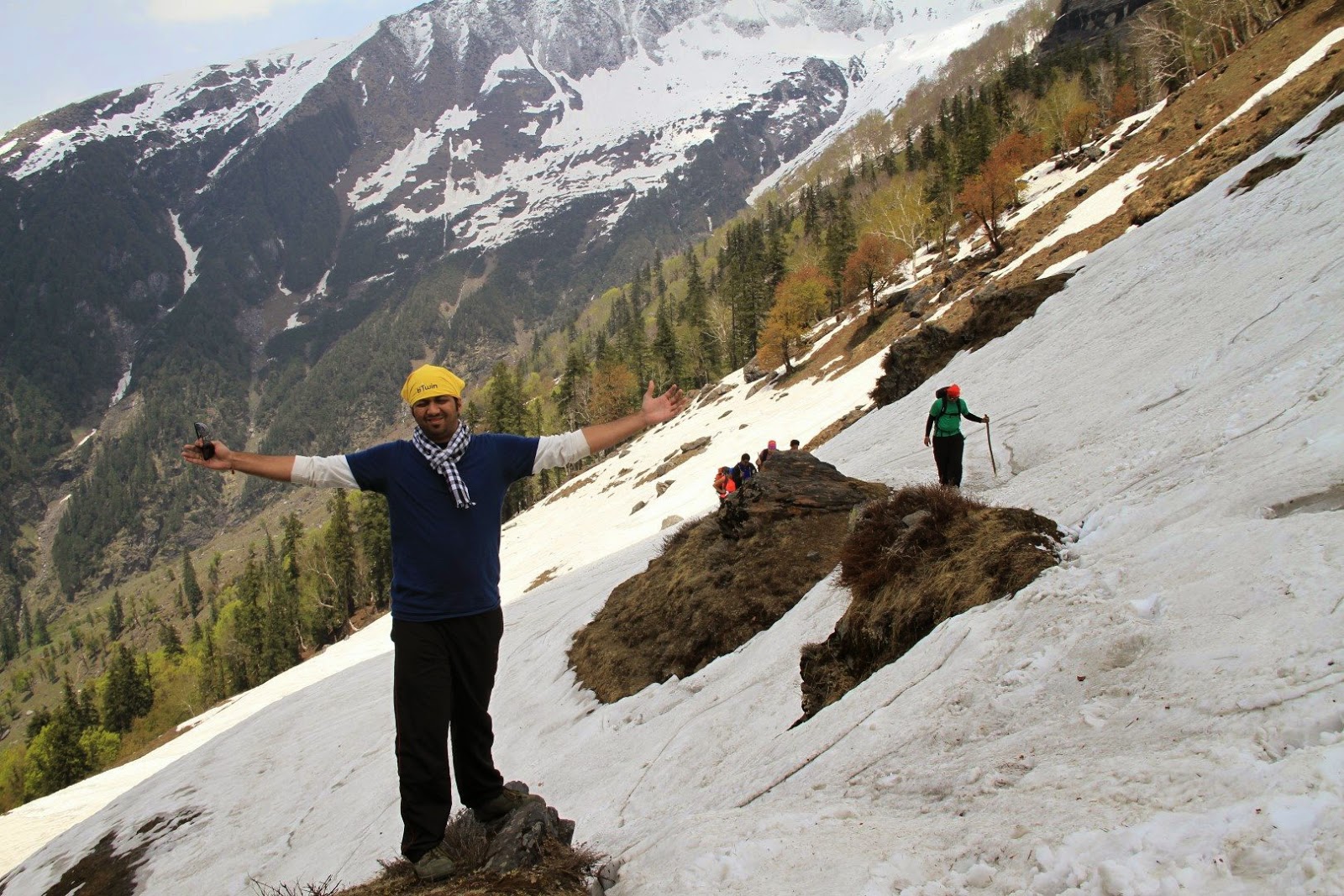
Five members of our team of sixteen had chosen to offload their luggage on the horses today. Others also partially offloaded. The least offloaded person, it seems, was Arpit due to his preparations for the HMI training course. We started shortly after with me being the last person to leave the campsite – again.

The initial ascent
PC: Sandhya Bhatre

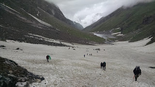
Our trail for the day immediately headed into snow and then alternated with grassy knolls and boulders. After about two hours into the day, we reached the actual Balu ka Gera campsite. Balu here refers to sand – not to be confused with ‘bhalu’ or bear. This campsite is an expanse of sandy plain divided into two by a tapered lake. The upper reaches of the hillock by the campsite was the only dry spot and we took a break here. The weather was now overcast, but thankfully the rains were away. From here on it was to be a stiff ascent to Hampta Pass top.

Balu Ka Gera
PC: Arpit Shah

Our first steep ascent through the snow was punctuated by a steep rocky ascent at its peak. The weather had started to deteriorate led by a drizzle with a mild breeze. The goat-herds overtook us here and assured (?) us that there was still a long way to go. The group had by now split into two distinct groups lead by Dinesh and Roshan respectively. Dinesh’s group included Shivani and Shakeel at the lead, me and Arpit floating and the rest in the middle. Roshan’s group included Sony, Tejal and Pritam, all of whom were somewhat struggling at the rear and were mostly beyond our eyesight for most of the ascent after Balu ka Gera.

Just beyond Balu Ka Gera
PC: Arpit Shah

Today was expected to be a long day. A total distance of about 11.5km and a stiff climb. This day typically takes about 8-10 hours. We had been walking for about 4 hours now, yet were nowhere in sight of the actual Hampta Pass. We were tiring and the weather was alternating between good and bad. Mentally, this would be a killer.

... to be continued in Part 2

© Kapil Pilankar

Saturday, 15 August 2015

Hampta Pass, Part3: Day2 Cheeka-Juara-Ferpatthar

Day2: Cheeka-Juara-Ferpatthar

The second day of the Hampta Pass trek usually starts at Cheeka and ends at Balu Ka Gera. We had assumed the same thing. However, much later in the day, after we had set up camp and downed tea were we told that the place where we were was actually the Ferpatthar campsite and about 2 hours hike short of Balu Ka Gera. Since, this was early in the season, the campsite at Balu Ka Gera had not completely dried out and hence would not be ideal. In any case, none of us was complaining after the already long and sapping walk.

The day, as is the norm in the Himalayas, started early and most of us were up by 5:30am. I'd had a not-so-comfortable sleep after having been relegated to the side of the tent with the bags. I'd almost used the bags as a side-pillow during the night. A slight drizzle early in the morning receded and the day eventually cleared up. We put out our slightly wet shoes, clothes and rain-shets out to dry in the sharp sun.

At the breakfast rock
L-R: Mayank, Sarita, Shivani, Sandhya, Pritam, Gauri
Uninterested: Tejal
PC: Arpit Shah

A hearty breakfast of bread, jam, honey, omelettes and porridge followed. I skipped the porridge. The condition of Pritam's shoes had deteriorated and had to be fixed with Fevi Bond and Fevi Kwik as a temporary solution. Also, bags for a few of our group were deposited on mules for the days hike to reduce their strain. We set off at about 9am after the day's instructions by Dinesh, our guide. I was the last person to leave the camp-site.

The route, Purvi & Charuta in the foreground
PC: Arpit Shah

Immediately after the campsite we had to negotiate a simple wooden drawbridge. The experience from Day1 proved handy in this case. The route quickly gained elevation along the right bank of the Allain Nala. Here we were passed by herds of sheep and goats brought by the local shepherds to cross over the Hampta Pass to Spiti - same as our route.

The sturdy Capris
PC: Sandhya Bhatre


Tejal was facing trouble with the stiff hike and so we exchanged bags. Mine was the lighter one. This might have just marginally helped, for soon we had our first snow traverse. The snow was stale, and being on a regularly used path, had taken on a dull colour. The traverse was done without any issue. The elevation of the path eased on from here on.

The "snow"
PC: Arpit Shah

Then came the big highlight of the day - crossing of an icy stream. The stream cascaded from a waterfall to our left to join the main branch of the Allain Nala on our right. The water was knee deep and icy cold. Hats off to the crew who put the rope and assisted in the crossings!

The Dreaded Crossing
VC: Arpit Shah

A 15-20 minutes walk from this crossing brought us to the Juara campsite where we had our pack lunch - plums, eggs and biscuits. The usable area at Juara is greater than that at Cheeka and hence it is also one of frequently used campsites on the route. By the time we left Juara, it was drizzling once again. The rain played on and off till we reached the Ferpatthar.

The view from the campsite
PC: Sandhya Bhatre

My pants, socks and shoes were partially wet due to the days happenings and then I'd to wait for the greater part of an hour for my bag to reappear. This was probably the last time I'd be swapping my bags with someone.

The campsite at Ferpatthar is - like Juara - very spaced out with easy slopes. Th campsite is called such due to the abundance of boulders that surround the campsite.

The rest of the day was spent relaxing by the nala and cursing the weather - dull and drizzle. A game of uno followed in the bigger tent and post dinner everyone was off to a peaceful sleep. All except Pritam, for his shoes were badly damaged and if no solution was found, he'd have to descend to Manali the next day itself without attempting the Hampta Pass. Fingers crossed ...

- Kapil Pilankar

Thursday, 30 July 2015

Hampta Pass, Part2: Day1 Manali-Jobri-Cheeka

Day1: Manali-Jobri-Cheeka

The first day of the trek began with overcast skies. By the time we had wrapped up our breakfast it had already begun to drizzle.

The overcast Manali morning
PC: Gauri Dixit

We packed our sacks with only the trek essentials and left the rest in our hotel. The list of trek essentials vary from person to person, so I’ll just put up my list for reference:
  • 1 full sleeve cotton tee + 2 dry fit half-sleeve tees
  • 1 army fatigue pants + 1 light cotton trek trousers
  • 1 thermal top
  • 1 rain/wind jacket + 1 doon feather warm jacket
  • 1 pair of trek shoes + 1 pair of sandals
  • 2 pairs of light cotton socks + 3 pairs of thick cotton socks + 1 pair of woolen socks
  • 1 pair of gloves + 1 monkey cap + 1 buff + 1 cotton scarf/napkin
  • torch + penknife + 3mtr. cotton sling (rope/lace)
  • band-aid + bandage + wet-wipes
  • anti-fungal dusting powder
  • water bottles 2+1 litre
  • 4 electral packets
  • 0.5kg dates
  • 1 packet of orange candy
  • 1 hand sanitizer bottle + 2 paper-soap sachet + 1 cold cream + 1 Vaseline + 1 toothpaste
  • 1 rain-sheet
  • 1 trek pole
  • 4 small snap-link carabiners
Out of these, the only unused items were the hand sanitizer bottle, cold cream, Vaseline and 1 pair of cotton socks each. I gave away the cold cream after it started to leak.

The trek arrangements had been done by Mr. Polu Ram, a local guide. For some reason he could not join us for the trek, and so his brother Mr. Dinesh was to be our guide for the trek. They came to pick us up with two Sumos. We set off for Jobri after a brief round of instructions.

The road to Jobri starts from a diversion on the Manali-Naggar road and climbs steeply thereafter. It’s a challenging road to drive on – not well maintained with potholes, streams and inclines. The road ends at the Allain Barrage, i.e. Jobri. It takes about an hour to reach here from Manali.

The road to Jobri
PC: Arpit Shah

There was a steady drizzle when we reached at Jobri and we took refuge under a make-shift tarpaulin shack. It turned out that the horses – mules rather – were not yet loaded and we would have to wait. Waiting at Jobri in relative dryness under the sheet was better than waiting at Cheeka where we would be exposed to the elements without the tents. We had a quick lunch of siddus (a local dish, similar to a hand-sized steamed momo) with chutney and chai. Pritam meanwhile found out that the sole of his shoes was about to come off. Luckily the shack owner had a stock of Fevi-Kwik which we used to patch him up.

Waiting at Jobri
L-R: Mayank, Sandhya, Shakeel, me, Arpit
PC: Arpit Shah

After waiting for more than an hour we set off for Cheeka. The ascent to Cheeka was gradual . We started along the left bank of the Allain Nala. The trail left the stream at places to climb into the deodhar and pine forest and then again descended lightly to the stream. The entire trail to Cheeka is straight-forward without any technical sections. After about 60% of the distance, the trail crosses over to the other bank of the stream over a makeshift wooden bridge. The gushing stream below might seem to be unnerving to some while crossing the bridge. The mules, after starting about half-an-hour after us, passed us at this point. Hereafter, we followed the right-bank.

Crossing the nala
VC: Arpit Shah

It was about 3pm when we reached the already crowded Cheeka campsite. The camp-able area at Cheeka is pretty small and already before us two groups had pitched their tents. One of these groups was a group of twenty-nine sexagenarians who we had met during the train journey from Mumbai to Delhi. We pitched our tents on whatever suitable ground we could find and then had a nice hot meal of noodles.

Tenting up at Cheeka
PC: Devendra Sawant

The tent arrangement was:
1x 4-man tent for the guys: me, Pritam, Shakeel and Devendra
2x 3-man tents for the girls: Tejal, sony, Purvi, Shivani, Gauri and Sonal
2x 3-man + 1x 2-man tents for the 3 couples: Mayank+Sarita, Arpit+Sandhya, Charuta+Aditya (rotation policy)

Birds-eye view of the Cheeka camp-site
Ours were the tents closest to the nala
PC: Sandhya Bhatre

After freshening up, we set off for an exploration of the waterfall next to the campsite. That was followed by a game of Uno in the guys’ tent. We wrapped up the games by sundown – 7:45pm. Soup was served by 8pm, followed by a simple dinner with dessert.

Everyone signed off to their respective tents by about 9pm and soon everyone was in their sleeping bags and off to sleep. Almost asleep that is .... :p

- Kapil Pilankar

Saturday, 18 July 2015

Hampta Pass, Part1: Trek Preps & Brief Info

Trek Preps

The trek to Hampta Pass was long awaited on my list. It was, after all, the logical followup to the partial Hampta Circle trek completed last year in May. The plan was set in motion by Mask around March 2015 and the near-final list was setup by the start of April.

The First Group Pic @ Mumbai Central
L-R: Devendra, Sonal, Aditya, Charuta, me, Gauri, Mayank, Pritam, Sarita, Shivani, Shakeel
Front L-R: Tejal, Sandhya, Arpit

The idea of preparing - physically - for the trek did cross my mind, and I nearly acted on it. However, my procrastinating self got the better of me and come June I was not in a decent shape for such a trek. My last trek of any consequence was the multi-day range trek from Ratangad-Katrabai-Ajoba-Kaladgad-Sadhale Ghat in the first weekend of March. The daily 65km commute from Mira-Road to Airoli also was an energy sapper.

In the one month before the big trek, I managed three treks - Raigad (hot and dry), Harishchandragad (first monsoon) and Raigad again (waterfall deluge). This meant my body was a bit used to the workload expected by the big trek.

The week preceding the trek was spent in some major last-minute shopping: Trek poles and shoes! The woollens would have to be purchased at Manali. Much of the packing was haphazard too, complicated by the formal attire for a training session at Bengaluru that immediately followed the trek.

The stupidest thing was that for the first time I was going to trek in an unused pair of shoes. Well, would have to deal with that there.

 New shoes!!!

-x-x-x-

Brief Information about Hampta Pass

Hampta Pass - Trek Map

The Hampta Pass trek begins at Jobri (barrage) near Manali. The trek route passes along the banks of the Allain Nalla which downstream from Jobri empties into the mighty and playful Beas. The trek ascends to about 14000ft. from the Kullu/Manali Valley before plunging steeply to the Spiti Valley to the other side. The stream on the Spiti side empties into the ferocious Chandra River that originates from Chandertaal. The trek ends at Chattru checkpost on the Spiti Highway.

Hampta Pass - Distances and Elevation Profile

The total trek distance is approximately 26kms. The trek has a substantial height gain of almost 4700ft. The major trek days are day two - from Cheeka to Balu Ka Gera - and day three - from Balu Ka Gera over Hampta Pass to Sheagoru. The third day involves almost 7-8 hours of snow walk.

- Kapil Pilankar

Sunday, 23 November 2014

My First Himalayan - Partial Hampta Circle - Day3: Srottu-Thatti-Tilgun

Day3: Wednesday, 21st May, 2014

It feels good when your body clock and stomach clock are in sync. That relieved feeling early in the day adds a certain enthusiasm. The enthusiasm is short lived when you realise that your stomach clock has malfunctioned and is triggering alarms every few minutes. Such was the start of this day.

The fact that to clear the alarms one had to trek downhill and then uphill for 70-80 feet didn't help matters. The Srottu campsite has two water sources and both involve a short hike, which in the rarefied Himalayan air feels like a major task. The best part of the day, however, was that the weather had cleared up with bright sunshine throughout enabling us to dry our wet ponchos.

Raunak enjoying the sunshine
Pic by: Krunal

I had a light breakfast, complemented by an Eno and some stomach soothing medication. The campsite was then duly wrapped up, We packed our eatables - same as last time. By 1000hrs were ready to go!

Leaving Srottu
L-R: Raunak, Arpit, Sandhya, Sarita, Mayank, Ishwar Dutt, Rudra Chand, Anmol, Nisha, Priya, Tejal, Chinmay
L-R sitting: Krunal, Pritam, me, Budhi Singh

Our plan for the day was to hike up to Thatti - the highest point of this route where we were expecting a lot of fresh snow -, spend some time there and then descend to the Tilgun campsite using a different route. The initial section from Srottu to the approximate snow line was to be very steep. After the snow line the incline tapered off, but the snow would increase the effort of walking. considering these factors, a few members of the group decided to have their bags ferried by the mules to Tilgun along with the kitchen equipment. The mules were to bypass Thatti and use a simpler shorter route.

The initial incline, as described, was quite steep with small stones and boulders dotting the landscape. The non-rocky sections were thoroughly covered by grass-like vegetation. The steep incline was negotiated using small switchbacks. We took frequent breaks during this ascent. Within an hour, we had our first glimpse of snow.

The initial incline after Srottu
Pic by: Krunal

The snow here was in small patches and visibly 'stale' - remnant of the winter snowfalls maybe. This however did not deter us from having a quick snow-ball fight. The snow gradually increased to swallow up the path at places. The rarefied air and poor stomach was taking its toll on me. A steady head ache had started to manifest. This could be ominous. 

The path through the snow
Pic by: Krunal

Short beaks were mandatory here for me to collect my self and my thoughts. We reached a section where the path was now completely lost to the snow. We had to ascend about 80 feet through fresh snow - 1 feet deep in some places. Budhi Singh taught us the technique - Hit the snow side-on with the boot, lean towards the incline and use the stick for balancing. We were trudging steadily through the snow. After this patch we reached a small clearing where we were asked to wait.

Chinmay trudging through the snow
Pic by: Krunal

The clearing was an area of 10x15 feet which was not covered by snow. Below us was the path though which we had just come and above was a longer stretch of fresh snow, beautifully inclined and perfectly set for some fun. This was precisely what the group set out to do. Snow-balls, snow-poses, poncho-sledding and skiing followed unabated for some time. I however opted to rest awhile to quell the headache. There was still some height to be gained and I did not want to over-exert at this point. 

Egyptians in the snow
L-R: Arpit, Sandhya, Sarita, Mayank
Pic by: Krunal

After the extended break we made our way for the final ascent of the trek, through the patch we had just played in. The snow here was an bit more difficult to navigate as compared to the previous patch, but most of us had grasped the technique needed and managed it easily enough. 

Arpit the Redeemer - Near the final ascent

From this point we made our way to Thatti - a ledge with a majestic view of the Fa-Konda range ahead and the Beas valley below. A brief halt to soak in the view - the beauty of the place - and then we were off. The descent had begun.

Chinmay and Ishwar Dutt with the Beas valley below
Pic by: Chinmay

The initial descent was steep. Gathering a footing at this point was a bit difficult due to the unsteady vegetation. We slowly and steadily made our way using small switchbacks. The descent then on alternated between patches through trees and vast sloping meadows. 

Starting the descent
L-R: Sarita, Mayank, Arpit
Background: Bhdhi Singh, Sandhya

We started the descent sometime around 1300hrs and reached Tilgun at about 1600hrs. As we were reaching close to Tilgun, a sense of deep melancholy overcame me. The feeling that I would be leaving these beautiful woods in not much time. A beautiful thing had started to end. I then slowed down to less than a stroll, soaking in everything that the place had to offer. Eventually, I could not even see the people ahead, nor the people behind. I was alone. And it was beautiful. 

By the time I reached Tilgun, the sun was about to set on the opposite range of the Beas valley. And fresh momos were waiting to be devoured. 

The kitchen tent - source of fresh momos

Tilgun as a campsite is pretty vast.  But most of it is occupied by the local sheep-folk and they leave their traces. The entire campsite is littered with sheep droppings. We managed to find a small clearing and pitched our tents. It was dark soon and we retired to our tents for the evening. 

The dinner was followed by an active campfire - song and dance stuff underneath the stars and pinged by a cold breeze. It was fun. We returned to our tents for the night - our last in the Himalayan woods.

- Kapil Pilankar

Sunday, 13 July 2014

My First Himalayan - Partial Hampta Circle - Day2: Baggi-Tilgun-Srottu

Day2: Tuesday, 20th May, 2014

The day begin on a bright note. Clear sunshine all around by 0600 hrs is something that I'm not accustomed to. But yeah, the morning views are amazing. The night was good too. The sleeping bag was warm and the sleep was good, if a little intermittent. I must have slept soundly for most of the night, judging from the fact that I noticed the snores from the neighbouring tent only after waking up!

The chores for the day included the additional tasks of wrapping up the tents and the sleeping bags after breakfast. Breakfast was good - omelets, bread, jam, butter and porridge. We were given some stuff packed for the trek too - mangoes, chocolates, frooti and a banana.

 Leaving Baggi
L-R: Raunak, Pritam, Chinmay, Anmol, Sarita, Mayank, Budhi Singh, Arpit, Sandhya
Sitting, L-R: me, Tejal, Krunal
Not pictured: Krunal's epic run after setting the timer

Our destination for the day was the campsite of Srottu via Tilgun. We left Baggi by 1000hrs. The initial section of the trek was an extension of the last day's trail to Baggi. The gradient and views were similar till we
reached the meadow of Tilgun. On the way Budhi Singh showed us an area that seemed to have been ploughed recently - handiwork of a bear. Tilgun was another high altitude meadow similar to Baggi. However, this one was more of an uneven kind and littered with goat poop. The reason, we later found out, was that Tilgun was used by the local goatherds as a camping site.

A break at Tilgun
L-R: Mayank, Sarita, Sandhya, Arpit
Pic by: Krunal

By the time we reached Tilgun, the weather had turned from sunny to overcast. We took a break here as our horse-cargo-train powered on past us.  There was a slight drizzle too. A group of students from Gujrat, in red ponchos, had trekked up to Tilgun from an alternate route. The had a few chants and then started their descent. The drizzle started again. We trekked up to a deodhar tree with a large enough canopy to shield our group from the drizzle. After the drizzle subsided, we started again. The route from here on had a steeper gradient and was very much exhausting. The tree cover thinned out drastically.

The Red Poncho Gang
Pic by: Krunal

The initial stretch of the trek had me sweating causing the inner layers to stick. The drizzle and the cold wind meant that the cold hit me harder over the stuck layers. Addition of my warm jacket for protection against the wind further complicated things. The rains we encountered here were mostly of  light to heavy drizzle type and nowhere as fierce as in the Sahyadris, but very cold. The rain-sheets that we had just about sufficed. A slight drawback was reduced mobility with one hand dedicated to holding the sheet - will need to find a workaround next time.

The trek continued in a similar fashion - steep stretches followed by breaks. On one such break I managed to doze off quite well. This break point was almost the end of the steep section and the tree line as well. A walk through boulders on a reduced gradient without any tree cover followed for some time. The tiredness had very well seeped in by then. It was almost 1430 hrs. The views of the beautiful mountains were also blocked by the overcast skies.

Between Tilgun and Srottu
L-R: Arpit, Samdhya, me, Sarita, Mayank
Above: Tejal
Pic by: Krunal

As we were trudging along, rounding of some nondescript bends and mounds, we were suddenly greeted by the sight of a campsite a little below our level. We quickened our steps only to realise that the tents were unfamiliar. The guides Nisha and Priya confirmed that they were of some other group and our campsite was further up. This was devastating to hear at that time. But then there was no alternative and the trudge continued.

Boulders with Arpit and Sandhya
Pic by: Krunal

A little ahead after five odd minutes a tent came into view to the right, some ten odd feet above the level of the path. Rudra Chand, the cook, came into view next and beckoned to join in the campsite. The joy then knew no bounds. I spent the next five minutes to ascend those ten feet - such was the exhaustion! It was almost 1615 hrs by the time we reached the campsite. All tents were thankfully pitched, partly in anticipation of rain and maybe partly due to our tiredness. Another great piece of news was that hot pakodas and tea was ready for us. A feast followed in the tents. Pakodas, mangoes and tea - very well acknowledged by a rumble in my stomach a short while later.

The campsite at Srottu was very small compared to the meadows of Baggi. Srottu is not a meadow, but a small section of level land on a steep slope. The campsite is shielded from winds by boulders surrounding it. The eastern and the western flanks have a stream each. The eastern one has a greater flow and is at a lower elevation - about 70 odd feet - than the campsite. The western one is quite thin and the usable part is about 70 feet above the campsite. Fetching water here would be a definite pain.

At Srottu, we were mostly indoors - or "intents", if the word exists - for most of the evening owing to the near persistent rain and a slight hail as well. We had a few card games before it was dark. We were off to bed early after dinner and hot tea at 2000 hrs. I did not eat much as my stomach was still rumbling.

A bit of hail - captured by Krunal

A quick mid-sleep pee break at about 2200 hrs when the rains had subsided gave a breathtaking view of Manali city below. It was a good way to end an exhausting day.

- Kapil Pilankar

Tuesday, 1 July 2014

My First Himalayan - Partial Hampta Circle - Day1: Manali-Shuru-Banara-Baggi

Day1: Monday, 19th May, 2014

This was the big day! We were to start off for our four day trek - my first in the Himalayas. The trek route was a part of the seven day Hampta Circle trek (not to be confused with Hampta pass which is at a higher altitude). Most of the major trek routes in the vicinity were closed off due to heavy snow. Hampta circle, as suggested by our guide Mr. Budhi Singh, was a viable option considering the low altitude, good weather conditions and the relative inexperience of our group.

The entire trek, as stated earlier, was to be completed in about four days. Two and a half days of ascent and the remainder for descent. The trek started at the small village of Shuru on the Manali-Jagatsukh road and ended at the comparatively larger Jagatsukh. We had three campsites: Baggi, Srottu and Tilgun. Our highest point was called Thatti. The camp supplies were loaded from Banara which was also the village to which Budhi Singh belonged.

We checked out of our hotel by 0930 hrs. The necessary items went in our sacks - spare clothes, water, some dry food and some items to keep the cold out - and the rest was deposited with the hotel management for safekeeping. We made our way to the start point split in a sumo and a rickshaw and alighted after crossing a small bridge after Prini village. A small pathway detached from the main road and wound upwards. This was the start of our trek. We had a quick round of instructions and dos-and-donts. Ms. Nisha and Ms. Priya, who also were our guides and assistants to Budhi Singh joined us here after a few moments.

The trek started with the chant of 'Ganpati Bappa Morya!' which brought about puzzled looks from our guides. The route was the approach trail to the village of Shuru. An initial steep ascent was followed by a level walk to enter the village. The route here was cemented as it was the principal access point for the village. There was no direct road. We reached Shuru village in about half an hour.

We crossed the main village to reach the Bhagwati Temple at its far end. The temple was beautifully constructed with alternating levels of stone and wood. Deodhar wood, to be precise. The area enjoyed a canopy of mighty deodhar trees on the higher slopes. The lower slopes were utilised for apple orchards. Any felled trees were utilized for construction and furniture locally. Felling of trees was obviously prohibited by law, but a quick look around would tell you that the law was not heavily enforced. The Bhagwati Temple has a beautiful facade with carvings of deities and a nice courtyard which can be used for resting. The view from here is beautiful with the Beas clearly seen snaking its way through the valley and the mighty snow-capped mountains visible on the other side.

The Bhagwati Mandir, Shuru
L-R: Chinmay, Anmol, Krunal, Arpit, Sarita, Mayank, Raunak, me, Budhi Singh, Sandhya
Pic By: Pritam

The route after the temple is actually a dirt track following the edge of the mountain and making its way towards Banara. The valley, the Beas and the peaks are visible throughout on this section. While on our way to Banara, Budhi Singh spoke of some local legends of Takshaknaag - the guardian deity of Banara and the areas we were to visit on our trek route. We reached Banara by 1115 hrs. We had a quick refill of our water bottles, followed by a break at Budhi Singh's house. Here we were greeted with a glass of Coke each! He had also arranged for a few trekking sticks and a makeshift cricket bat.

Between Shuru and Banara
Pic By: Chinmay

Our next stop was the Takshaknag Temple, located on the higher slopes at the outskirts of Banara village. The temple has a similar design to the Bhagwati Temple at Shuru. We rested a while in the open space outside the temple and then started the comparatively steeper hike to Baggi. The trail was a well laid out stone path amongst the tall deodhars and pines. The trail continued on the moderately steep gradient with a few switchbacks and straight patches.

The Takshaknag Temple, Banara
Pic By: Chinmay

Between Banara and Baggi
Pic By: Chinmay

A little while later, Budhi Singh asked us to deviate from the main path to a short steep track of about 20-30 steps. At the end of the track was the beautiful campsite of Baggi. The campsite was a high-altitude meadow with fresh grass at a very moderate gradient. The meadow was surrounded by vegetable patches and apple orchards on the eastern, western and southern sides. The norhtern side dropped quickly to the main trail. The campsite had a pipe acting as a watersource at the north-eastern corner. Pipe drew fresh water from the melting snow at the higher altitudes and supplied to the campsites and villages below. The main open patch near the western end was reserved for the sleeping tents. The kitchen tent was halfway from the sleeping tents to the water pipe.

Baggi

It was already 1400hrs by the time we reached Baggi. At Baggi, we met the remainder of the crew. Mr. Rudra Chand was the camp cook and porter. Mr. Ishwar Dutt was the assistant guide, porter and helper. Mr. Negi minded the horses. We were taught to pitch a tent by the staff. the first one was a demo. We pitched two others. The fourth was pitched earlier. Hot lunch followed. We rested for a while and then had a game of cricket. The game was interrupted twice - once when the bat snapped in two, and then when the ball went in the apple orcherd next door. The apple orchard incident put an end to the game.

Tent pitching
L-R: Tejal, Chinmay, Negi-ji, Raunak, Anmol, Krunal
Pic By: Pritam

Maggie Time
L-R: Krunal, me, Mayank (front, blue), Pritam (back, green), Sarita, Arpit, Sandhya
Pic By: Chinmay

Post tea, we visited the southern edge at Baggi. Here, beyond the fields, was a narrow ledge with a steep drop of around 120-150 feet. The valley felt strangely peaceful here. the beautiful views were however obstructed by the tall trees. We were later reprimanded by Budhi Singh for venturing too close to the edge. During the return, we collected some wood for the campfire. A game of cards followed.

Dinner was early at 2000hrs. We had a nice, bustling campfire session followed by a cup of hot Bournvita and then were off to bed by 2230hrs.

Note: We observed quite a few bone fragments - all cattle - in and around Baggi. These were quickly attributed to a bear which resided in the mountains nearby. The guides said that the bear resided in a cave which in the summers was filled with such bone fragments of what was once cattle and then bear-food.

- Kapil Pilankar

Sunday, 8 June 2014

My First Himalayan - Partial Hampta Circle - Background and Build-Up

Mask Group took its first steps into the Himalayas under the guidance and management of YHAI through its National Level Sar Pass Trek; part of the SP-14 batch in 2013. Mayank, Arpit, Sandhya, Avinash, Aakash, Jay and Sneha spent some astounding days there.

Sar-Passed!
L-R: Sneha, Jay, Aakash, Mayank, Sandhya, Avinash
Behind the camera: Arpit Shah

YHAI's Sar Pass - In Action

I had missed out then at the last moment due to work commitments. I spent that entire period sulking and just managed a consolation backpacking trip to Devgad-Kunkeshwar over the weekend. Not as lofty as the Himalayas, but serene nonetheless.

Kunkeshwar Temple and Beach
Source - Google

A year later, just after the event at Phansad, Arpit and Sandhya came up with the plan to Join YHAI's Chanderkhani Pass Trek in May. This, like last year's Sar Pass trek, needed a leave of about 10 days which most of us could not manage: Mayank was newlywed in late Jan and had taken an obvious long leave then; I had recently switched jobs and was still on probation. Others had similar reasons. However, everyone wanted to do it. Or, maybe, at least one Himalayan in May. It was simple - we HAD to do it!

Chanderkhani Pass - Late Summer
Source - Google

A quick lookup showed that the Chanderkhani Trek was possible in 3-4 days if privately managed. This meant arranging a guide, crew and supplies locally or lugging everything on our backs all the way from Mumbai. The second option was definitely not feasible. Another search popped up the name of Mr. Budhi Singh who worked as a guide near Manali. The name was backed up by enough positive reports to warrant a call. We confirmed his availability, the approximate rates and the list of services he would provide. He confirmed that we would only need to manage ourselves and he could take care of the rest - the food, crew, logistics, equipments, etc. Perfect! We had our first Independent Himalayan Trek on our hands!

Another round of discussions followed. We did not want to make our first independent Himalayan a toughie. Chanderkhani Pass is known to have some difficult climbs on loose rocks which we felt could be a bit hazardous for a possibly inexperienced team. Another set of options was searched - this time in conjunction and consultation with Mr. Budhi Singh - and we narrowed down on Beas Kund.

Beas Kund is a small lake at the mouth of a glacier and is the source of the Beas River. The lake and, by extension, the river derive its name from a local misnomer of Ved Vyas who was said to have meditated here. The place is surrounded by majestic peaks on three sides and opens up to the Beas Valley on the fourth. This valley acts as the access to the lake and the loftier peak of Hanuman Tibba beyond.

Beas Kund - Late Summer
Source - Google

The Beak Kund Trek was to last a total of four days. An additional side-trip to Amritsar was added. The final plan was hatched with the following itinerary:

Day0: 16th May, Friday
Depart from Mumbai to Delhi in Duronto Express at 2330hrs

Day1: 17th May, Saturday
Arrive in New Delhi by 1630hrs
Board the bus to Manali by 1730hrs

Day2: 18th May, Sunday
Arrive in Manali by 0800hrs
Meetup and discuss with Mr. Budhi Singh
Spend the day acclimatizing and shopping for any pending stuff

Day3: 19th May, Monday
Trek Starts
Depart early morning to Dhundi via Solang Nalla
Trek from Dhundi to Bakhar Thatch
Spend the night in overnight camp at Bakhar Thatch

Day4: 20th May, Tuesday
Trek from Bakhar Thatch to Beas Kund
Spend the night in overnight camp at Beas Kund

Day5: 21th May, Wednesday
Return trek from Beas Kund to Bakhar Thatch
Spend the night in overnight camp at Bakhar Thatch

Day6: 22nd May, Thursday
Return trek to Dhundi
Transfer to Manali
Side trip to nearby places if time permits

Day7: 23rd May, Friday
Early departure for Amritsar
Late evening arrival at Amritsar

Day8: 24th May, Saturday
Siteseeing around Amritsar for half a day
Proceed to Delhi by 1130hrs in Sarayu Yamuna Express
Arrive in Delhi by 2000hrs
Depart for Mumbai from Delhi by 2330hrs in Duronto Express

Day9: 25th May, Sunday
Arrive in Mumbai by 1700hrs

The train bookings and hotel reservations were accordingly done. Shopping was managed in bits and pieces according to stock and our avaialbility. By first week of May almost everything was set and the excitement was reaching the peaks - literally, the countdown had begun!

And then on Wednesday, 14th May, two days before our scheduled departure, Mr. Budhi Singh called in with some bad news - heavy snowfall had made the trek to Beas Kund almost out-of-bounds for the next one month. Their personal recce the day before was largely unsucessful from our point of view. However, we were assured that the trek would go on. No, not Beas Kund, but some other route. A local one perhaps. The detailed discussion would happen ow on Sunday at Manali. This bit of information was known to only few members of the group - me, Mayank, Arpit and Sandhya.

Anyways, most of the motley group assembled at the Mumbai Central Railway Station by 2230hrs. I had managed to reach Borivali by then; I was running a bit late at the start and a late local train services delayed me further by 20 mins. In the end I reached the station by 2320hrs; just 10mins before the scheduled departure.

A partial group pic :(
L-R: Arpit, me, Mayank, Sarita, Tejal
Crouched, front: Pritam
Behind the camera: Sandhya
Missing: Krunal ,Raunak, Anmol, Chinmay

Everyone, as expected, was in high spirits for Beas Kund while all I could manage was a silent "lol"...

Photo credits (non Google) - Arpit Shah

- Kapil Pilankar

Ads Inside Post